When we lived in Minnesota, we heard the geological tales quite often of how the 10,000+ lakes were jewels left behind by the glaciers during the last major ice age. A "cool" process to think about, but tough to truly envision how it happened. That is, until we crossed from Canada back into the United States and were greeted by the snow-capped peaks of southeast Alaska. We had arrived in a place where glaciers are still actively and dramatically shaping the land.
This narrow strip of Alaska's panhandle, famous for its islands, fjords, mountains, and glaciers, is surprisingly remote from the rest of the state. Planes, boats, and ferries are the main means of accessing and moving between the islands of this archipelago. Roads from Canada lead into the Alaskan towns of Haines and Skagway, and that is how we boarded the ferry to take us to ...
Glacier Bay National Park
... a magical place where glacial wilderness sparks scientific wonder.
Since 90% of Glacier Bay’s visitors only experience the park from the deck of their cruise ship, snapping a photo with the official park entrance “sign” felt quite special.
A Little History/Geology/Glaciology Lesson
From a geological perspective, the land that surrounds Glacier Bay National Park is quite new. Prior to 1750, the Glacier Bay area was a lush green valley with salmon-rich streams and scattered forests in which the Huna Tlingit Nation called "home". A great glacier lay dormant in the distance. But the Little Ice Age from 1750 to 1780 quickly changed this tranquil hamlet. Grand Pacific Glacier, a massive river of ice 100 miles long and thousands of feet deep, quickly encroached on the Tlingit hunting grounds and homeland. Scientists estimate that the fast moving glacier would have advanced around 350 feet per day. This catastrophic event forced the Tlingit to relocate to Hoonah, a nearby island.
But just as quickly as it advanced, the massive sheet of ice retreated. In its place a deep bay formed that is now 65 miles long.
When naturalist John Muir visited this area in 1879, he described Glacier Bay as ...
"Sunshine streamed on the intensely white, far-spreading fields of ice making a picture of icy wilderness unspeakably pure and sublime grandeur"
John Muir
His rich descriptions inspired a steady stream of visitors, from nature lovers to science buffs, that continue to this day.
A Living Laboratory
Because of the relative "newness" of this geological event, Glacier Bay National Park has become a world-class natural science lab as its wilderness continues to experience stages of regeneration and growth.
From its tidewater glaciers,
to its moss-laden rainforests,
to its entertaining wildlife,
scientists and naturalists have been drawn to one of Mother Nature’s most fascinating research sites.
Biologist William Cooper's study of plant succession convinced government officials to make Glacier Bay a national monument (and later a national park) in 1925. His studies helped us understand how plant communities gradually replace one another in a fairly predictable sequence, often following a disturbance like this massive glacier retreat. Studies like this also paved the way for research and education by park staff that continues today.
Another success story is how the National Park Service was able to develop a partnership with the Huna Tlingit people as they welcomed them back to their ancestral homeland.
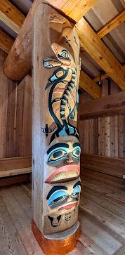
In addition to the Park Service's visitor center and lodge, a Hana Tlingit Tribal Ceremonial House now overlooks Glacier Bay.
This intricately designed structure provides a "home" for cultural celebrations as well as a location for the Hana Tlingit to share the story of their ancestral connection to Glacier Bay with visitors to the park.
Getting to Glacier Bay National Park can be a little tricky as well as pricey, but in our quest to visit as many national parks as we can, it seemed "easy" compared to the bush plane flights that will be needed in order to reach each of Alaska's four other remote national parks. Bringing our “home” with us meant boarding a ferry from Skagway to Juneau, then continuing on to Gustavus ... where a single paved road links the tiny village to Glacier Bay National Park, ten miles down the road.
Because the ferry only travels there twice a week, we had four days to enjoy this serene wilderness. We stayed at a small and very well maintained RV park in Gustavus. Because of the "scientific" nature of this area, many of its residents have a passion for wilderness studies. One morning we met and enjoyed a delightful visit and an interesting lesson on the habits of mosquitoes from Harvey, a retired science teacher.
During our four days in Gustavus and Glacier Bay, we found ourselves constantly in awe of the breathtaking scenery that surrounded us.
Mountain View Road actually has a beautiful mountain view!
It was a scenic ten mile drive to the park's visitor center that sits on the shore overlooking Glacier Bay. In addition to the visitor center, there’s a rustic lodge, a cozy restaurant, a tour boat dock, a primitive campground, and occasional bear droppings that remind you who really hangs out here.
Heeding those multiple signs of bear activity in the area, Doug made sure to carry our bear spray as we enjoyed hikes through the lush rainforest. There we found a favorite treat for humans and bears alike ... salmon berries that weren't quite yet ready for picking.
During the evenings, we attended the ranger talks where we learned about animal migration, nature and wildlife sounds, glacier formation, and plant secession after the glacier retreat.
But the highlight (and partially the reason why a visit to Glacier Bay can be a bit expensive) was our eight hour catamaran tour that we booked through Glacier Bay Lodge and Tours. The $273 ticket included a light breakfast, a sandwich lunch, an informative park ranger narrative and amazing wildlife "shows" including a pod of orcas playing "who can catch the sea lion breakfast first?"
like bears,
and sea lions,
and puffins.
As we journeyed further up the bay, the clouds dissipated. The sun shone brilliantly as our captain brought our vessel closer to the John Hopkins Glacier than one could ever dream of while on a much larger cruise ship.
In an age where 95% of Alaska's glaciers are shrinking in size, this is one of the few Alaskan glaciers that is still advancing in size. This is mainly due to the massive amounts of snow that blankets the surrounding mountains all year round. We're especially happy that Mount Fairweather lived up to its name that day!
and we feel incredibly lucky to have experienced even a small part of its vast beauty.


.jpg)


.jpg)


