"The road to success is not always paved with a straight and easy path."
Anonymous
Sometimes it leads you around curves and up over high mountain passes,
sometimes it forces you to take a leap of faith over deep gorges,
and sometimes, no matter how hard you try, it throws a rock your way.
Yet despite the challenges, our journey along the Alaska Highway has been filled with breathtaking beauty mile after mile (or kilometer after kilometer, depending on which side of the border you are on).
The story of this important link between two countries is a story of international determination and cooperation.
In March of 1942, the United States Army Corps of Engineers and the Canadian government knew that they certainly didn't have a straight and easy path ahead of them. After the bombing of Pearl Harbor on December 7, 1941, they realized that the war had suddenly gotten too close to home. Both countries feared an invasion of the North American west coast ... a region that was strategically vital but incredibly remote and difficult to access. In an effort to secure an overland route to supply and defend that vulnerable coastline, the United States and Canada worked together to construct one of North America's most important and iconic roadways ...
The Alaska Highway.
This 1700 mile road, completed just 8 months later, provided a secure land route to move troops, weapons, and supplies north quickly in order to defend Alaska from enemy attack. In the years following the war, the highway has been re-engineered and realigned in places, so today, it measures about 1,390 miles long. With the modern day improvements, it continues to serve as an important link for commerce and tourism between Canada and Alaska ...
We drove the western half of the Alaska Highway in the summer of 2022 on our way back from Alaska. During that time, we drove on possibly the roughest part of the highway ... from Delta Junction, Alaska to Watson Lake, Yukon before heading south on the Cassiar Highway. That section is especially difficult because permafrost, wild weather, and remote conditions make it a constant struggle to maintain a rut-free road.
This summer it was time to complete our Alaska Highway journey when we found ourselves at the eastern starting point ... "Mile 0" in Dawson Creek, British Columbia.
We started this summer's Alaska Highway journey a little before the "official" Mile 0, when we headed north from Jasper National Park. Here, the mountains give way to Alberta's northern plains once again. From our overnight location in the charming small village of Grande Cache, the peaks of the Northern Rockies could be seen in the distance.
As I wandered through a giant labyrinth in one of the town’s many scenic parks, I found myself lost in beauty of my surroundings.
And despite being in the middle of nowhere, we once again enjoyed some international deliciousness at a local restaurant.
Step aside, Canadian poutine ... it’s sushi’s turn to shine!
Just outside of Dawson Creek, the Walter Wright Pioneer Village's collection of early 20th century buildings
and artifacts
... offered a glimpse into what life was like before the Alaska Highway connected this and other remote Canadian villages to the outside world.
Despite the increased traffic, these towns retain their charm as they warmly invite travelers to stop and stretch their legs for a bit by ...
A couple of our favorite Alaska Highway "must stop" locations this time around included:
Liard Hot Springs Provincial Park
This hot spring fed pool in the middle of a lush spruce forest is a favorite "re-charging" station for weary travelers.
And while we are always hoping for sunny and 70,
we were happy to put up with a few rain drops and a little "chilliness" knowing that 110-125 degree hot spring water awaited us!
Watson Lake Signpost Forest
After leaving the town of Fort Nelson, there is a long stretch of amazing beauty as the highway summits the Northern Rocky Mountains, but, unfortunately, not much of any other kind of "services".
So when we reached Watson Lake, we were happy to be connected to civilization once again as we checked out its claim to fame ... the Signpost Forest.
Here, what began with a home-sick soldier in 1942, has developed into an explosion of craziness. American GI Carl Lindley hung a sign from his hometown of Danville, Illinois on a tree here and unwittingly planted the seed for this unique "forest".
Besides the hours of entertainment that you get while wandering through the forest until you find one from your neck of the woods,
the town also offers free boondocking and all the other services that weary travelers would need including the all important ... Gas, Lattes, Showers, and Internet!!!
Carcross Desert
At this point, we left the Alaska Highway to head toward the southeast panhandle of Alaska. Suddenly, we began to wonder if we'd gone a little too far south as we found ourselves surrounded by a desert-like landscape.
We've left the Alaska Highway for now, but with our travels in the past, we're happy to know that we have covered all 1390 miles of not necessarily straight,
or easy roads,
but definitely roads full of entertaining roadblocks,
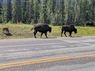
friendly roadside greeters,
and beauty that is found along every mile (or kilometer) of North America's Iconic Roadway ...
Print this post


.jpg)


.jpg)


No comments:
Post a Comment